Abstract
The history of the Minoan eruption of Thera and the subsequent caldera formation is reconsidered. It is upheld that the collapse of the Stronghyle volcano occurred in two phases : the first accompanied the end of the eruption, at whatever time it happened (c. 1500 in the traditional chronology ; c. 1628 in the revised chronology). The second took place some 400 years after.
The Greek archaeologist Sp. Marinatos has been the first to recognize the importance of the volcanic explosion of Thera (Santorin) during the Minoan times. However, when he invoked the Theran volcanic events to explain the destruction of the palace centers in Crete, he created a whole string of controversies. Since his first paper published more than fifty years ago, a lot of work has been done by archaeologists and scientists to prove or disprove the Marinatos theory. After three international Symposia and the publication of about 400 papers, it seems that a consensus has been established (see in particular H. Pichler & W. Schiering in ArchSol. Anzeiger, 1980, p. 1-37) on the following points:
1) The eruption of the Theran volcano occurred c. 1600 + 75 B.C., without a noticeable break. Its duration has been estimated from one day to a few weeks. Thanks to dendrochronology and analysis of the ice-cores from Gro'ndland, it has been possible to reach a more precise date: 1628 BC. However, some archaeologists still do not accept this "revised chronology" arguing that it does not necessarily concern the Theran eruption. Therefore, they retain the traditional date: c.1500 BC.
2) The formation of the ensuing caldera by collapse of the volcano began (emphasis added) at the end of the eruption.
3) The tephra-deposit occurred at the end of the Late Minoan IA period. It has been huge on Thera itself (the layer of tephra is about 75 feet thick) but pretty light on Crete (only a few inches thick). As a consequence, attributing the destruction of the Minoan Civilization in Crete (which happened at the end of the Late Minoan 1B) to the eruption of Thera becomes hazardous. How can one explain the gap in the pottery sequence?
4) The traces of a "tsunami" c. 1500 BC that Sp. Marinatos and some other archaeologists have allegedly found in Amnisos and elsewhere are not convincing. Sp. Marinatos himself recognized that he "could not reconcile the (traces of an intensive) fire with a terrible inundation caused by the sea."
In spite of the fact that a consensus seems to have been reached on the above points, the original theory has evolved from a general acceptance to an array of chaotic positions, some contrary to the laws of Physics! For instance, some scholars, in order to explain the absence of a tsunami at the time of the eruption, have gone as far as supposing a kind of "gentle, progressive subsidence"!
We will not discuss about the exact date of the volcanic eruption, which has to-day become the greatest controversy, as it has been established during the Third International Congress on Thera. Neither will we contradict the here-above cited paper by Hans Pichler and Wolfgang Schiering, which has been considered by many scholars as "a final criticism" of the Marinatos theory, except on one point: "What has been the importance of the tsunami subsequent to the collapse of the old volcano called Stronghyle?" We cannot accept the theory that the collapse of the volcano has been a kind of progressive, gentle subsidence, without any important tsunami created. The collapse and sinking into the sea of a 500-600 meter high volcano (in the most moderate estimate. [Cf H. Pichler & W, Friedrich (8) p. 26 ] cannot have been nothing else than a sudden and brutal event ! Neither can we consider the theory of a "pre-eruption caldera" as sufficiently proved. Such a theory (the pre-eruption shape of the island would have been pretty similar to what it is to-day) has been suggested by the analysis and radiocarbon dating of stromatolites and gastropodes, which have shown that sea-water filled areas existed on the island prior to the Minoan eruption (See U.Eriksen et al in "Thera III" ). But these areas could have been just "lagunas", not necessarilly a "caldera" ! It is probable that the shape of the pre-eruption island was not a very regular cone, as it had been first thought by the geologists. But, the volume of the ejected material shows that the collapse of the volcano into the sea MUST have created a huge tsunami !
Also, as there is no way to place a one-phased collapse at the time of the eruption, whatever its date from 1700 to 1400 BC, we have to suppose a one-phased eruption followed by a two-phased collapse (not a multi-phased gentle collapse as supposed by H. Pichler & W. Schiering ). The first collapse occurred c. 1500 (in the traditional chronology) or in the year 1628 (in the revised chronology), at the time of the burial of Akrotiri under pumice and tephra. It created only a limited tsunami. The second one happened about 300-400 years later and was accompanied by a huge tsunami, which has affected many coastal Mediterranean countries.
The aim of the present paper is to develop the arguments in favor of this theory.
1) The following reconstitution of the volcanic events is absolutely compatible with the archaeological data:
An eruption and a first collapse at the end of the Late Minoan IA period are in agreement with what has been found at Akrotiri.
On the other hand, as brilliantly demonstrated by L. Pomerance (see 1O and 11), the general havoc recorded c. 1200 BC in the whole Mediterranean World could be better explained by the consequences of the second collapse than by the ubiquitous intervention of the "Peoples of the Sea"
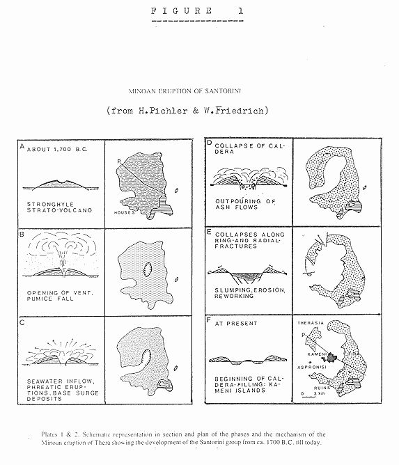
2) The volcanic history of Thera, as reconstructed by the geologists and in particular by H. Pichler & W. Friedrich (see 8), is in favor of a collapse with two phases (Fig. 1, phases D and E). That these two phases have been separated by a 300-400 year-span of time is unusual but not impossible (as would be a multi-phased collapse). It is a well known fact that rocks in unstable equilibrium may stay a very long time without collapsing, until some earthquake triggers their falling-down. Precisely so, there have been several strong earthquakes at the "End of the Bronze Age", as it has been shown by diverse authors.
Following our calculation, the collapsed area during the First Phase would not have exceeded 14.5 sq. km, i.e. a surface representing about 17 percent of the total area. The outline of this "first caldera" would have been approximately the same as the outline of the 115-Bouguer anomaly, with the probability that seawater did not engulf the collapsed area. The resulting tsunami would have been therefore quite mild, without disastrous consequences in spite of a 5 to 8 cubic Km volume of collapsed material.
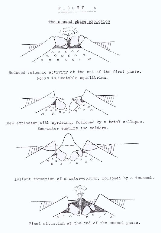
The same cannot be said about the second collapse, which must have had a tremendous impact c. 1200 BC on the entire Mediterranean area. The most moderate estimate of the total volume of collapsed material being in the range of 34 cubic Km. This is in good agreement with the estimated volume of the magma chamber and of the quantity of tephra ejected Cf N.D. WATKINS et al.(see 12). A rough calculation has lead us to a minimum volume of 26 cubic Km sinking into the sea. A prior earthquake fissuring the half-consolidated rocks resulting from the first collapse and bringing the seawater in contact with the hot magma shall have triggered the second collapse. A tremendous explosion should have followed, leading to a subsequent collapse and tsunami formation (Fig. 4).
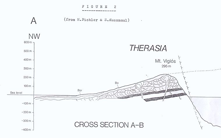
Arguments that there has been indeed a terrific tsunami when the second collapse occurred can be found in the anomalies of the geological map and of the soil data. From the geological map, it appears that the top layer of the Upper Pumice Series [ = Bor layer of the geological map established by H. PICHLER & S. KUSSMAUL (see 9) ] has been washed away on the inner part of the Santorini islands facing the center of the caldera. However, it was left partially in place on the outer part, where it has been reworked and was resedimented by the sea-water brought by the tsunami and by ulterior rain-wash. Such a conclusion is particularly clear from the cross-section AB of the Therasia Island reproduced in our Fig. 2. The erosion of the upper layer is mainly due to tsunami-action: it would not be that regular and that total on the upper part of the hill with rainfall erosion because rainwater follows preferential paths, carving ravines and valleys, and letting patches of less eroded material between them.
[NOTA : We do not ignore that the origin of this upper layer has been open to controversy. Pichler, Kussmaul and Friedrich believe (as stated hereabove) that it is a layer of reworked material. Some others (Heiken and MacCoy, Sparks and Wilson) argue that the deposits would be ignimbrites. We personally believe that this last hypothesis is wrong.]
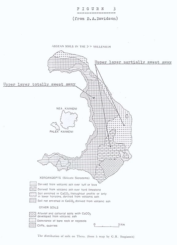
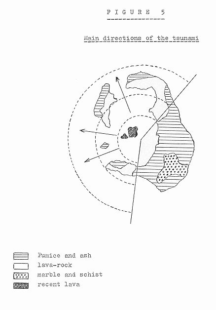
The same conclusion that a tsunami has "washed" the soil of the island can also be deduced from the soil map established by D.A. DAVIDSON (see 2) and reproduced in our Fig. 3. This map confirms that the upper tephra layer has been washed away in the Western part of the Thera Island, as expected from a tsunami action. Due to the geographical disposition of the caldera, it seems that the tsunami was mainly directed towards West (Greece) and North (Troy) than East (cf Fig. 5).
The washing-away of the top layer explains why any remains of settlements dated from 1500 to 1200 BC have not been found. Such settlements have probably existed but the tsunami from the second collapse has completely obliterated all traces of them.
The study of the "Augias turbidite" has provided us with more direct proofs of a huge tsunami. This has been traced at the Ionian and Sirte Abyssal Plains and the adjacent slopes of the Calabrian Rise and the Mediterranean Ridge (See papers by W.Hieke and F.Werner in "Sedimentary Geology Vol 135 (2000) p. 205-218, and by M.B. Cita and G. Aloisi , ibidem p.181-203). The authors said that the date of these pelasgic turbidites would be "c.1500" from the C14 analysis, but a date of 1200 BC seems not to be outside the error-margin.
Other external proofs of the tsunami --a lot more precisely dated-- can also be found and show that it occurred later than the eruption. The most interesting one is the existence of a pumice deposit on the Northern coast of Cyprus. In a paper published in 1975, M. FORNASERI et al.(see 4) have identified the deposit, situated in the upper part of a raised beach about half a mile from the shore line, as being partly from the Minoan eruption of Thera and partly from another source. As tsunamis do not transport floating material but do uplift over the littoral zone a half-sunk pumice raft that has been pushed along the coast by the winds and the surface streams, we have to conclude that the tsunami occurred years after the eruption. In addition, if we take into account the dating of some archaeologically stratified finds from the same area (See P. Astrsm in 1) , we may deduce with some confidence that the tsunami should have occurred c. 1200 BC. Analogous deposits lifted by a tsunami over the sea level have been found at other places (Amnisos, Island of Anaphi, coast of Palestine). However, the evidence that such a tsunami is related to the Thera eruption and occurred c. 1200 is less conclusive (See J. YOKOHAMA in 13 and J. KELLER in 5).
The two-phased collapse theory is also supported by the map of the Bouguer anomalies established by I. YOKOHAMA & V. BONASIA (Thera I p. 147-150), which we have used for our calculations. The central low gravity area corresponds to the "first caldera"
SELECTED BIBLIOGRAPHY
The Proceedings of the Second International Scientific Congress, Santorini, Greece, August 1978 , edited by C. Doumas under the title: Thera and the Aegean World, London 1978 & 1980, are cited as: Thera I & II